Case studies

Showing results 11 - 15 of 15
Case Study Impacts of the 2019–20 bushfires on the Gondwana Rainforests of Australia World Heritage Area and the benefits of restoring traditional fire regimes

Andy Baker, Tasmin-Lara Dilworth and Oliver Costello

The importance of the Gondwana Rainforests of Australia World Heritage Area

The 2019–20 Black Summer bushfires affected 24 of the 50 reserves in the Gondwana Rainforests of Australia World Heritage Area (GRWHA), sparking major concerns for their globally significant rainforest values (DAWE 2020d, Nolan et al. 2020). Together, these reserves protect the largest stands of remnant rainforest in subtropical eastern Australia, and support a high diversity of endemic and threatened rainforest biota (DAWE 2020d). Despite its name, rainforests in the GRWHA typically occur as discontinuous patches within a matrix of fire-dependent eucalypt forest. These eucalypt forests are also recognised as significant integral values of the GRWHA because of their evolutionary and ecological interrelationships with rainforest, and their inherent deep antiquity and threatened species habitat values (Bradstock 2016). The GRWHA is also a significant cultural landscape for many Aboriginal groups with connections to the cultural and natural values present, including the values of grassy and open forests as traditional pathways that connect people and significant places (Mcintyre-Tamwoy 2008).

Assessing the negative and positive impacts of the 2019–20 bushfires

Preliminary mapping suggested that approximately 50% of the GRWHA was affected by the 2019–20 bushfires (DAWE 2020d, Nolan et al. 2020). However, further ground truthing indicated that the extent of fire-affected rainforest is less than first anticipated (DAWE 2020d). For example, on-ground validation of fire boundaries in the Nightcap Range reserves (see Figure 18) found that fires were largely restricted to forests with fire-dependent eucalyptus and brushbox in the canopy, and that fires typically self-extinguished within 30 metres beyond boundaries with core rainforest (DPIE 2021). Despite this, rainforest biota was extensively affected where fires burned the rainforest understorey beneath sclerophyll canopy.

Assessments and monitoring indicate a remarkably high resilience and recovery of subtropical, littoral, dry and warm temperate rainforest. Assessment of postfire response across 8 GRWHA reserves found that around two-thirds of woody rainforest plant taxa were either strong resprouters or postfire seeders (Nicholson et al. 2020). Similar rates have been found in other postfire studies of Australian rainforests (e.g. Marrinan et al. 2005, Campbell & Clarke 2006, Williams et al. 2012), further demonstrating the high resilience of rainforest to occasional fire (Bowman 2000). Several threatened species are showing signs of recovery, including the rufous scrub-bird (Atrichornis rufescens), stuttering barred frog (Mixophyes balbus) and red bopple nut (Hicksbeachia pinnatifolia) (DAWE 2021). Despite strong indicators of resilience, the recovery of some taxa remains uncertain due to restricted distribution (e.g. nightcap oak – Eidothea hardeniana) or confounding impacts such as myrtle rust (e.g. peach myrtle – Uromyrtus australis) (Kooyman 2020). Overall, these early results suggest a strong potential for long-term recovery. Previous postfire studies of Australian rainforest show that rainforest structure can regenerate quickly after fire. For example, Williams et al. (2012) found that rainforest trees resprouting from ground level returned to pre-fire heights (4–8 metres) within 3 years.

Most of the sclerophyll forests affected by the 2019–20 bushfires in the Nightcap Range reserves were chronically overdue for fire (Baker & Catterall 2015, Bradstock 2016, NPWS 2018), and these fires are likely to have been largely beneficial in these ecosystems, triggering widespread reproduction of open forest flora and restoring early successional habitat (e.g. Whelan 1995, Chapman & Harrington 1997, Kelly et al. 2017). In the absence of fire, dry sclerophyll forests in the region are vulnerable to rainforest pioneer and exotic weed invasion (Lewis et al. 2012, Tasker et al. 2017, Baker et al. 2020a), and the subsequent elimination of open-forest flora and fauna (Baker et al. 2020a, Baker et al. 2020b). For wet sclerophyll forests with an inherent rainforest understorey, rare wildfires are also believed to be a crucial part of the natural regeneration cycle (Keith 2004, Kenny et al. 2004).

Figure 18 Fire scars left by the 2019–20 bushfires in Nightcap National Park

Photo: © NSW National Parks and Wildlife Service

Predicting climate change effects on fire regimes in the Gondwana Rainforests of Australia World Heritage Area

Fires in the Nightcap Range rainforest are not unprecedented, with charcoal evidence of pre-European fires in subtropical rainforest every 300–1,000 years (Turner 1984), and modern intervals of less than 50 years in warm temperate rainforest (Floyd 1990). However, the effects of climate change on fire regimes in the GRHWHA are uncertain because of the many synergistic and antagonistic effects driving climate–fire–vegetation feedbacks (Bradstock 2010, Keeley & Syphard 2016).

Under normal climatic conditions, rainforest fuel structure and microclimate typically suppress fires at their boundary (Hoffmann et al. 2012, Little et al. 2012). However, this effect is likely to be muted under the hotter and drier conditions predicted across many parts of eastern Australia (Collins et al. 2019), leading to more frequent fire incursions into rainforest. Conversely, elevated atmospheric carbon dioxide (CO2) accelerates rainforest expansion into open forests, leading to the suppression of understorey fuels and a more sheltered microclimate, potentially facilitating rainforest expansion even with increased fire frequency (Bowman et al. 2010, Wigley et al. 2010). Indeed, the dominance of closed forest in past CO2-enriched climates (McElwain 2018) suggests that increasing temperature and seasonal drought can be overridden by the fire suppression feedbacks associated with rainforest fuel arrays (Girardin et al. 2013, Bond 2019).

Understanding the benefits of healthy fire regimes in the Gondwana Rainforests of Australia World Heritage Area

Maintenance of both rainforest and sclerophyll forest values are explicit objectives for the management of the GRWHA (Bradstock 2016). The restoration of appropriate fire regimes in fire-dependent ecosystems adjoining rainforest areas holds promise for maintaining both rainforest and sclerophyll forest values in an increasingly changing climate. First, research elsewhere indicates that planned burns in sclerophyll communities can mitigate the spread of unplanned fires into adjacent rainforest (King et al. 2008, Bradstock 2016), primarily by reducing the intensity, rate of spread and extent of fires approaching rainforest boundaries. Second, the long-unburnt status of many sclerophyll communities in the GRWHA and their vulnerability to degradation from rainforest pioneer invasion warrant the restoration of traditional fire regimes to maintain open forest structure and composition (Bradstock 2016). Additionally, planned burns have been shown to reduce wildfire severity within sclerophyll forests (Hislop et al. 2020), while cultural burning can effectively protect fire-sensitive refugia (McKemey et al. 2020).

Ultimately, the extent and severity of bushfires in modern Australia are linked to the demise of Aboriginal landscape fire and exacerbated by climate change (Bowman 1998, Bird et al. 2008). The restoration of historical fire regimes through cultural burning practices can play a key role in the recovery and ongoing protection of GRWHA values (Bradstock 2016), including the restoration of biodiversity, cultural pathways and connection to Country.

Case Study Bushfire impacts on cultural values and the revival of cultural burning in Banbai Country

Banbai rangers and Michelle McKemey

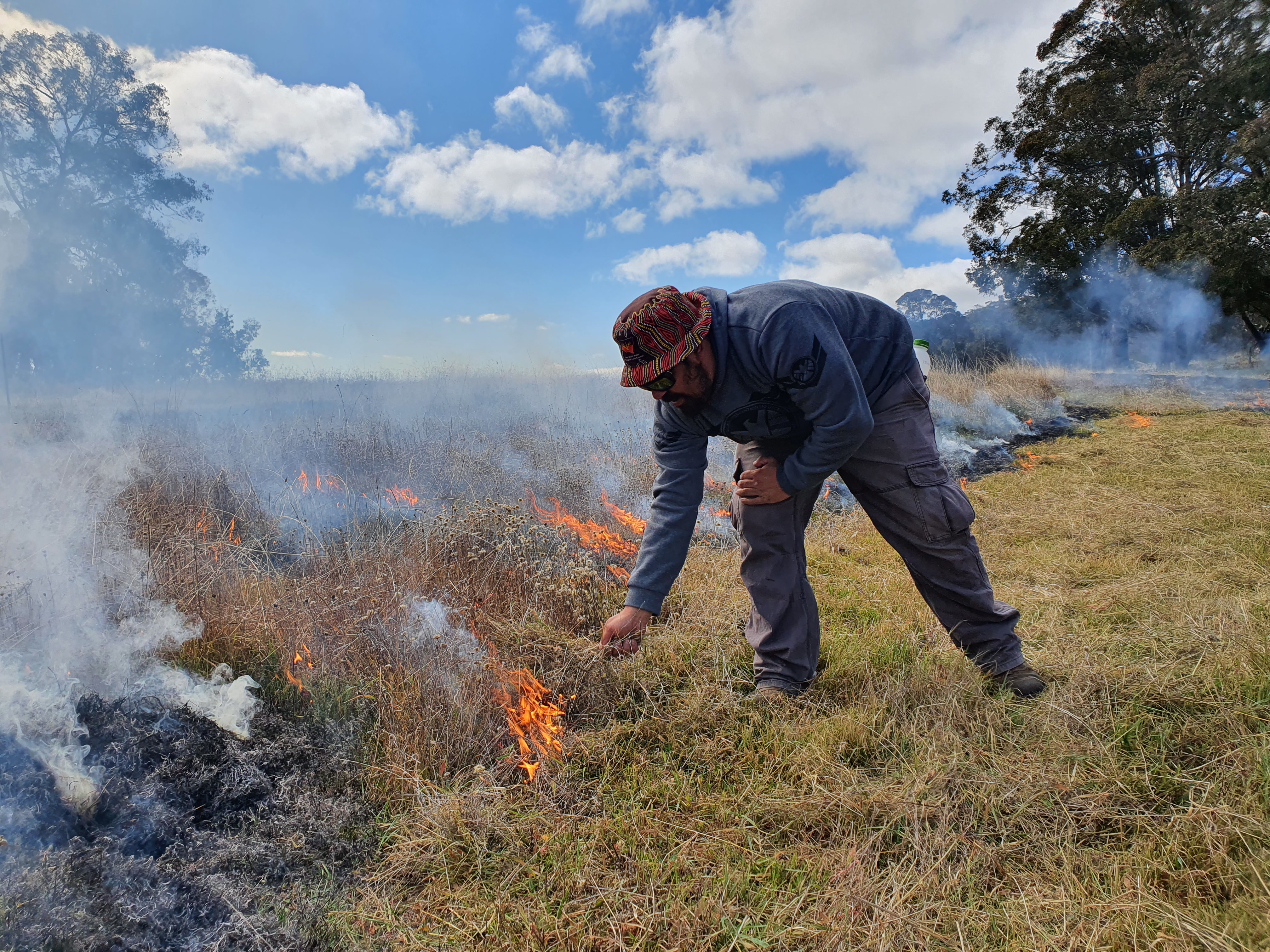
On the New England Tablelands of New South Wales, the Banbai rangers manage the 480-hectare Wattleridge Indigenous Protected Area (IPA) for the conservation of biodiversity and cultural heritage (Patterson & Hunt 2012). Despite disruptions to their traditional cultural practices (Sonter 2018), the Banbai rangers started to renew their cultural fire management from 2009 (Figure 21):

Until 2009, we didn’t do any cultural burning at Wattleridge IPA and then we started to reintroduce a few burns, which made the land a bit healthier. After the burning we saw more animals, more native plants coming through, and very few weeds. Cool burning leaves habitat behind for animals, birds, and plants. The canopy is sacred, and we try not to burn it. My Mother taught me how to put the fire out, and to have respect for it. She used to burn every year … Fire is a good tool, but it can also be destructive, and knowing how to work with fire is a benefit for the people, the Country, and the animals. Cultural burning has given us a chance to get out on Country and get to know it better. (Lesley Patterson, Banbai Elder and ranger)

Figure 21 [EXT_19a] Figure 21 A cultural burn undertaken by Banbai rangers at Wattleridge Indigenous Protected Area

Photo: Michelle McKemey

In 2013, the Firesticks Project partnered with the Banbai rangers to enhance cultural burning at Wattleridge IPA (Figure 22), as well as supporting Michelle McKemey to undertake the PhD project ‘Developing cross-cultural knowledge (‘right way’ science) to support Indigenous cultural fire management’ at the University of New England. This cross-cultural monitoring program monitored the impact of cultural burning on a totemic species, the kukra (short-beaked echidna, Tachyglossus aculeatus), and a threatened plant species, the backwater grevillea (Grevillea scortechinii subsp. sarmentosa) (Figure 23). It also involved co-production of Winba = Fire, the Banbai fire and seasons calendar (McKemey & Banbai Nation 2020, McKemey et al. 2021c):

We have been working together to develop Winba = Fire, going out on Country to look at the plants that are flowering and fruiting, the birds that are coming and going, what the wallabies are doing, the snakes becoming active in the warm weather ... We burn in autumn and winter to make it safe for the Country and people, so it is not going into a wildfire – we can control the winba during the cooler months. (Lesley Patterson, Banbai Elder and ranger)

Figure 22 [EXT_19e] Figure 22 Banbai ranger Dominic Cutmore lighting a cultural burn at Wattleridge Indigenous Protected Area

Photo: Sam Des Forges

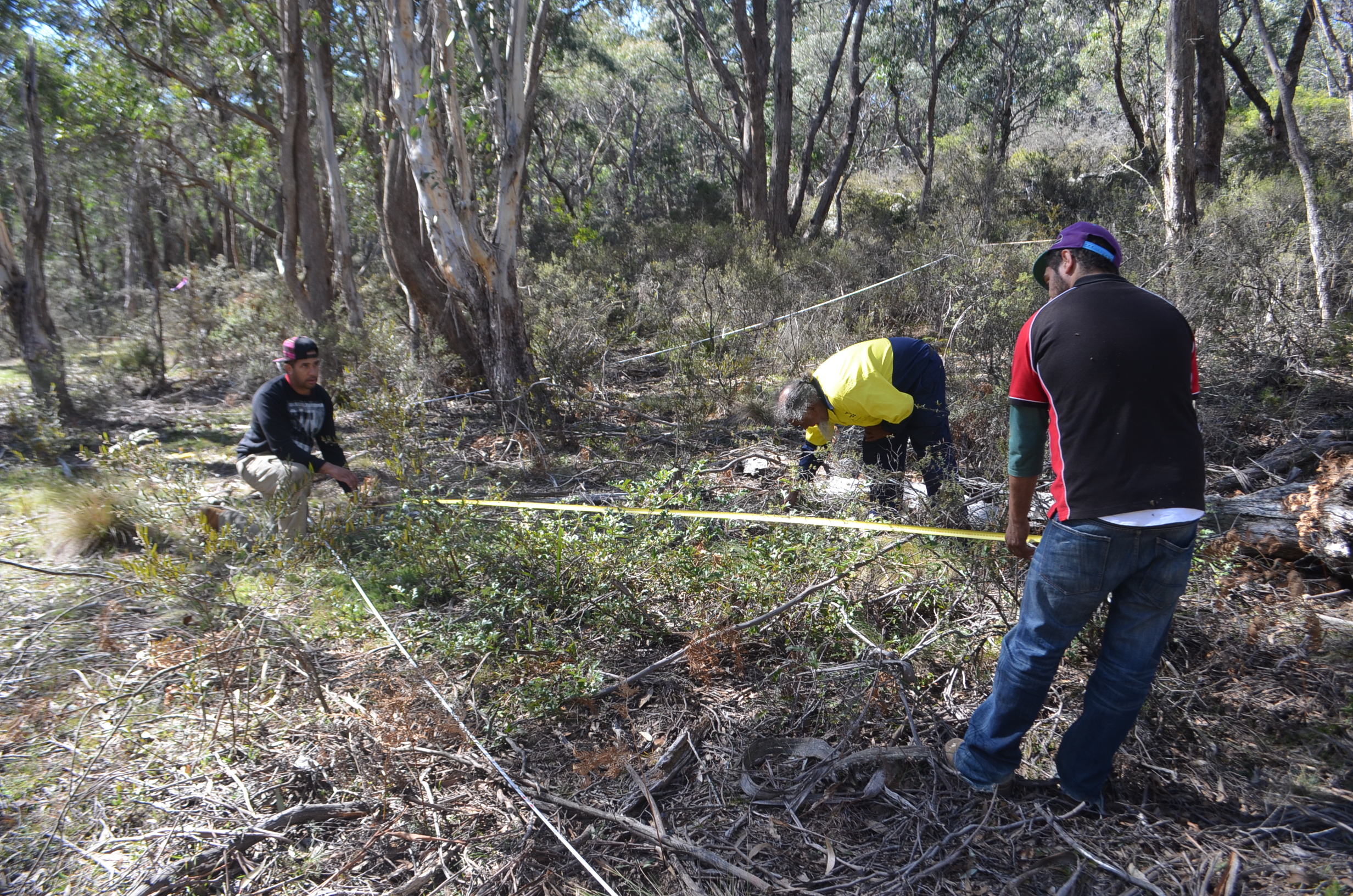
Figure 23 [EXT_19c] Figure 23 Banbai rangers Cody Patterson, Tremane Patterson and Mervyn Torrens measuring a threatened backwater grevillea as part of a long-term cross-cultural monitoring program at Wattleridge Indigenous Protected Area

Photo: Michelle McKemey

The cross-cultural monitoring program found that cultural burning did not affect the kukra at Wattleridge IPA, possibly to enable echidnas to avoid predation, whereas a higher-severity hazard reduction burn at neighbouring Warra National Park impacted echidna habitat and foraging activity (McKemey et al. 2019):

Cold, mosaic burns are best for the kukra, the ones that don’t come through and burn everything out like logs and all that, open them up for predators so definitely low burns and cool burns. (Kane Patterson, Banbai ranger)

The cross-cultural research also concluded that cultural burning resulted in lower mortality of mature backwater grevillea and less impact on reproductive output than bushfire. Both the Crown Mountain bushfire and cultural burning at Wattleridge IPA stimulated a mass germination event, but the cultural burn preserved a multi-aged population, whereas the wildfire killed 99.6% of mature grevillea shrubs (McKemey et al. 2021b). Comparison of fuel load changes resulting from cultural burning, hazard reduction burning and wildfire indicated that fuel loads were reduced by all fire treatments, although the cultural burn was less severe than other fires (McKemey et al. 2021b).

When the Pinkett bushfire came through as part of the 2019–20 Black Summer bushfires, prior cultural burning managed to save a rare rock art site of cultural and archaeological significance (Figures 24 and 25) (McKemey 2020a):

We had performed a cultural burn at Kukra rock art site prior to the severe bushfire that hit Wattleridge. Our cultural burn helped us to stop the bushfire from reaching the rock art and we were able to protect it, unlike other cultural places in the region that, unfortunately, were damaged by the bushfires. (Tremane Patterson, Banbai ranger)

Figure 24 [EXT_19b] Figure 24 Banbai ranger Tremane Patterson surveying Indigenous rock art at Wattleridge Indigenous Protected Area that was saved from bushfire damage following preparations by the Banbai rangers, including cultural burning and protective measures

Photo: Michelle McKemey

The collaborative study provided quantitative and qualitative evidence of some of the cultural, social, ecological and wildfire management outcomes of Indigenous cultural fire management. Cultural burning promoted regeneration (McKemey 2020b), did not burn the canopy, reduced fuel loads (McKemey et al. 2021b) and had less impact on wildlife habitat (McKemey et al. 2019) than other fires. As part of this process, the Banbai rangers were empowered to share their story of cultural fire renewal, which was undertaken by their community in a post-colonial nation-state where fire management has been altered since European settlement. Most importantly, the study demonstrated that Indigenous cultural fire knowledge and practice are alive, even in areas where the impacts of colonisation were severe, and can be renewed under supportive circumstances. This process of revitalising culture, caring for Country and co-producing knowledge is relevant for many Indigenous communities around the world (McKemey 2020b, McKemey et al. 2021c). The Banbai rangers intend to continue and expand their cultural burning program, as well as providing mentorship to others, noting:

Us Banbai rangers have got the knowledge and the know-how to do it on our own property. Cultural burning is the way to go, you know your canopy and the old trees are going to survive if you do low-intensity burns. It does the Country better, it doesn’t take as long to come back, as it would with a wildfire. (Lesley Patterson, Banbai Elder and ranger)

Figure 25 [EXT_19d] Figure 25 Fire damage to Wattleridge Indigenous Protected Area and Warra National Park following the Black Summer bushfires of 2019–20

FESM = fire extent and severity mapping

Source: Michelle McKemey

Case Study Savanna burning

Andrew Edwards and Jeremy Russell-Smith, Charles Darwin University and North Australia and Rangelands Fire Information

Despite the obvious signs of climate change in the decade to 2020, especially increasing numbers of hot days of more than 35 °C, fire management in many locations across northern Australia’s annually flammable savanna landscapes has fundamentally improved. This improvement is attributable to development and implementation of a collaborative approach, involving both Indigenous fire management and scientific knowledge traditions, widely known as ‘savanna burning’. The approach has involved applying traditional Aboriginal landscape fire management through extensive implementation of low-intensity early-dry-season fires to ‘break up the country’ and reduce the risk of late-dry-season wildfires. It has also involved complementary development of market-based methods to account for reducing greenhouse gas emissions, particularly from late-dry-season wildfires, through prescribed early-dry-season fire management. Over the past decade, outcomes from enhanced savanna burning fire management have been delivered mostly on Indigenous-managed lands.

Across Australia, European colonisation in the 19th and 20th centuries brought about the removal of Indigenous people from their lands and the demise of landscape-scale Indigenous fire management. From available accounts, such fire management in many savanna regions involved the creation of mosaics comprising mostly lightly burned, interconnecting patches functioning as a firebreak network (e.g. Garde et al. 2009). With colonisation, the lack of such firebreaks across the landscape has meant that, once ignited, late-dry-season fires can become unstoppable, commonly burning tens of thousands of square kilometres. In 2004, for example, late-dry-season wildfires burned more than 60% of the Arnhem Plateau, an area of 30,000 square kilometres that contains the Northern Territory’s terrestrial biodiversity crown jewels.

This kind of fire occurrence was common in many parts of northern Australia until savanna burning approaches provided incentives for land managers to undertake more sustainable fire management through early-dry-season prescribed burning. Since implementation of the formally legislated savanna burning methodology in 2012, a quarter (around 300,000 square kilometres) of the entire eligible savanna region (receiving more than 600 millimetres of mean annual rainfall) is now registered under a savanna burning project (Figure 26).

Contemporary prescribed burning emulates traditional Indigenous burning practices, but also uses a range of technologies such as aerial ignition from helicopters to precisely and efficiently drop incendiaries to manage fuels over large tracts of country, and satellite-based fire mapping tools for planning and monitoring. Originally developed to assist Arnhem Land fire managers, the North Australia and Rangelands Fire Information (NAFI) fire mapping portal is now widely used for fire management applications across northern Australia and central Australian rangelands, and for associated greenhouse gas emissions accounting in the savannas.

NAFI has a number of map products that illustrate the location of fires. The first, and most viewed, is the ‘active fire’ information called ‘hotspots’, derived from Earth observation satellite images collected a couple of times a day. Each visible point on the ground, called a pixel, represents about 1 square kilometre. Although at a relatively coarse spatial scale, hotspots represent the thermal energy of an active fire-affected pixel in relation to the pixels around it. This active fire information is particularly useful for locating fires in remote areas and identifying imminent wildfire threats.

A second product is referred to as burnt area mapping (BAM). BAM uses slightly higher-resolution MODIS satellite images (250 m × 250 m pixels) to observe the amount of near-infrared light reflected from plants. By comparing 2 observations, before and after a fire, we can detect whether an area has been burned because some, or all, green plant material will have been destroyed – we can identify the pixels likely affected by fire. Obviously, this works best where there is moderate green vegetation cover. Where there is too much canopy, the effects of understorey fires may not be detectable; with too little canopy, there may be too little relative change to be certain.

The BAM product is mapped nearly weekly, reviewed monthly, then compiled and reviewed annually. The northern Australian fire season occurs every dry season, typically from May to October. There is relatively little fire activity outside this period; therefore a ‘fire year’ arbitrarily runs from January to December to encompass the dry season. The annual BAM product has been created since 2000, allowing us to create some very useful fire history metrics (Figure 27), such as the frequency of prescribed fire, the frequency of late-dry-season wildfire and the cumulative fuel age at any time (enabling determination of wildfire risk). Using these simple fire metrics and more sophisticated species modelling, the effects of fire regimes on biodiversity can be predicted. All these information layers are available on NAFI, and can be used in fire management planning and operations.

The NAFI fire history information is validated regularly and exceeds 90% accuracy. This level of reliability, the extent of its coverage over whole tropical savannas and rangelands, and the development of associated accounting tools has, since the mid-2000s, underpinned the creation of a new regional landscape-scale fire management industry delivering reduced greenhouse gas emissions, retention of landscape carbon stocks and improved biodiversity conservation outcomes. Importantly, it has also provided culturally relevant employment opportunities for many Indigenous land managers and communities across northern Australia.

Figure 26 Properties engaged in savanna burning in northern Australian tropical savannas

mm = millimetre

Figure 27 Fire frequency in northern Australian tropical savannas, 2000–20
Case Study Researchers call on citizen scientists to report severe weather

Joshua Soderholm, Dean Sgarbossa and Alain Protat, Bureau of Meteorology

Australian researchers are calling on members of the general public who are fascinated by severe weather to take part in a citizen science initiative that will better capture the occurrence of severe weather events and improve our ability to understand them. Citizen reports of severe weather are critical because such events are often localised, are of short duration and happen at ground level, and therefore it can be difficult to quantify the associated hazards from standard instrumentation (weather radar and weather stations). Furthermore, measurement of the size of hailstones is only possible from citizen reports.

Citizen reports of severe weather have been collected by the Bureau of Meteorology’s Storm Spotter Program during the past 3 decades through telephone, mail and web forms. This rich dataset has provided invaluable information for understanding Australia’s thunderstorm risk (e.g. Allen & Karoly 2014), for forecast verification and for in-depth analysis of hazards (e.g. Allen et al. 2021). With the advent of smartphones and new communication platforms, a new approach to collecting citizen reports is required to ensure the continuity of this dataset in the future.

The key to modernising citizen reports is the WeatheX app, designed by scientists from the Australian Research Council Centre of Excellence for Climate Extremes, Monash University and the Bureau of Meteorology. The WeatheX app aims to modernise Australia’s capacity for reporting severe weather events by using the functionality of smartphones to deliver real-time information and photographs. The app was carefully designed to provide a user-friendly, engaging interface, while protecting the user’s anonymity.

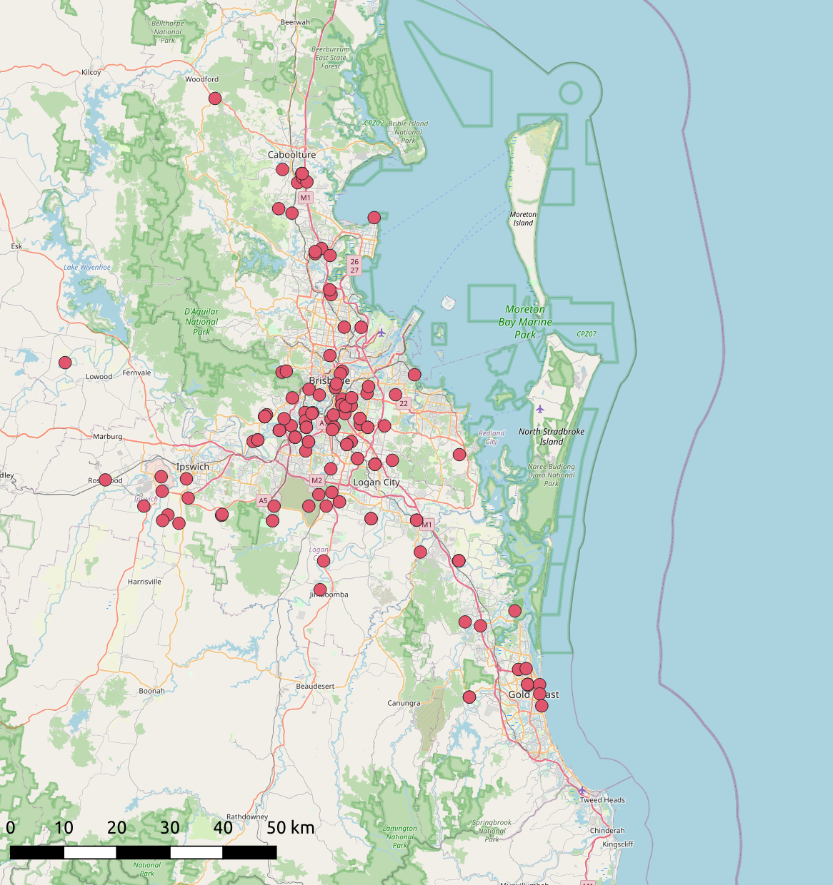
Since its launch in late 2018, the WeatheX app has collected more than 3,400 reports, of which 10% include photos of the severe weather event. Reportable hazards include hail, heavy rainfall, damaging winds and flooding. Most recently, WeatheX users submitted 242 reports during the Brisbane hailstorm on 31 October 2020, the largest number of reports for any severe thunderstorm event in Australia. There were 134 hail reports (Figure 28). The largest measured and photographed hailstone recorded in Queensland’s history was observed during this event (Figure 29). Analysis of WeatheX reports and other meteorological datasets has allowed an in-depth investigation of this exceptional event.

Figure 28 WeatheX hail report locations from the 31 October 2020 event

km = kilometre

Figure 29 Largest hailstone observed in the 31 October 2021 event (maximum diameter of 13 centimetres)

Photo: Niel Gentile

WeatheX strives to remain relevant and effective for the Australian public. Future improvements are expected to include integration with existing apps and weather products, and new applications for this dataset in verification, warnings and climate services.

Acknowledgement: Data used in this case study were collected through the WeatheX app. These data are held by the Bureau of Meteorology and available on request.

Case Study Virtual expedition – detecting the Kangaroo Island dunnart after fire

Erin Roger, Atlas of Living Australia, CSIRO

Citizen scientists have answered the call to assist in bushfire recovery efforts for one of Kangaroo Island’s most endangered species. Before the 2019–20 bushfires, the Kangaroo Island dunnart population was listed as Critically Endangered, with its population estimated at 300–500 individuals. The dunnart is only found on Kangaroo Island in South Australia, so there was considerable concern about its persistence after the fires burned more than 90% of its habitat. A team from the South Australian Department for Environment and Water, and the Kangaroo Island Landscape Board established a monitoring project and set up more than 90 cameras in the vast national parks of western Kangaroo Island to try to locate remaining individuals.

Each remote camera is deployed for 2 months and will capture thousands of images during the 2-year program. For a project of this magnitude, the team needed help to review each image and identify species photographed. The team turned to citizen science to help solve this challenge – citizen science is all about the power and potential of scale, and that by working together we can do more. The project team formed a partnership with the Australian Museum to use the Wildlife Spotter feature on the DigiVol crowdsourcing website. DigiVol is run by the Australian Museum and is supported by Atlas of Living Australia infrastructure.

To date, more than 1,300 citizen scientists have contributed their time and expertise to review the nearly 200,000 images loaded on the platform (e.g. Figures 30 and 31). One dedicated individual has reviewed images from every expedition since the project started in March 2020. Participants are mostly from across Australia, but there are also enthusiastic individuals from around the world. The identified animal photos are helping to draw a picture of the distribution and abundance of the surviving animal populations; the team picked up 33 new locations of the dunnart in the first 6 months.

The project initially focused on the unburnt area, but later realised that there are significant populations remaining in the burn scar, and there are now equal numbers of sightings inside and outside the burn area. This is important for future prioritisation efforts.

The Department for Environment and Water indexes and tracks photograph identification through DigiVol and verifies outputs to generate data. These data are helping to inform recovery actions for other native species on the island, such as Rosenberg’s goanna and the Kangaroo Island echidna. The information gathered is also helping to support on-ground fauna surveys of rare species, such as the Kangaroo Island southern emu wren and other cryptic species. This people-powered project is also providing valuable information for invasive species programs.

The project will continue to run, enabled by the Australian Museum and Atlas of Living Australia collaboration, with regular batches of images for sorting by the community. Anyone can participate (go to the Bushfire Recovery Projects page on the DigiVol website. This is a great example of the benefits for science and society of engaging a wider cohort of people in disaster monitoring and recovery.

Figure 30 [EXT_26b] Figure 30 Kangaroo Island dunnart captured by motion-sensing camera

Photo: Kangaroo Island Fire Recovery, South Australian Department for Environment and Water

Figure 31 [EXT_26a] Figure 31 Kangaroo Island dunnart, a small marsupial found only on Kangaroo Island

Photo: Peter Hammond

Acknowledgement: The Kangaroo Island Dunnart Survey team comprises 3 key partners: the Kangaroo Island Landscape Board, the South Australian Department for Environment and Water, and Kangaroo Island Land for Wildlife, which have been working before and after the fire with funding from the Australian Government. This citizen science initiative is a partnership between these organisations, the South Australia Wildlife and Habitat Bushfire Recovery Taskforce, and the Australian Museum. DigiVol is a crowdsourced digitisation platform that was developed by the Australian Museum in collaboration with the Atlas of Living Australia. See also Protecting and detecting the Kangaroo Island dunnart (Hohnen 2019).